Tag Archives: general

South_Carolina_R_7_So_called_dollar_of_1st_Meeting_of_General_Assembly_in_1791_01_qt

South Carolina R-7 So-called dollar of 1st Meeting of General Assembly in 1791

South Carolina R-7 So-called dollar of 1st Meeting of General Assembly in 1791

South Carolina R-7 So-called dollar of 1st Meeting of General Assembly in 1791
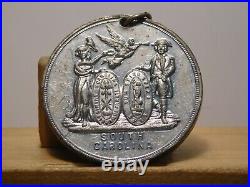
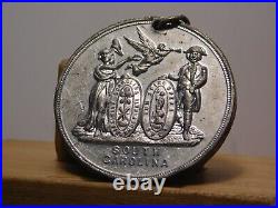
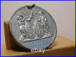
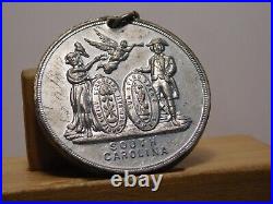
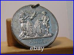
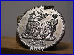
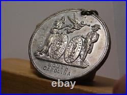
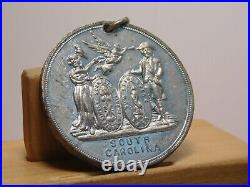
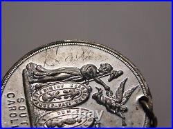
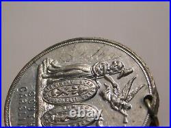
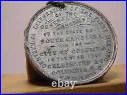
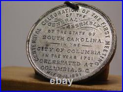
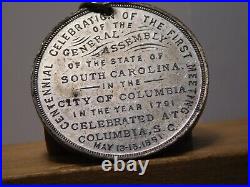
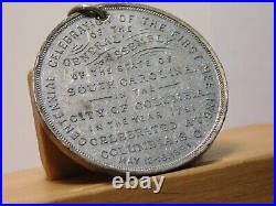
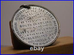
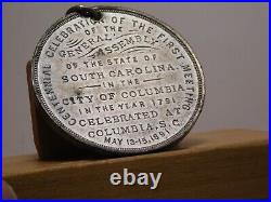
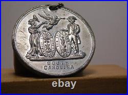
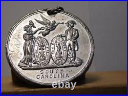
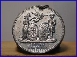
891 South Carolina so-called dollar H-K 622, R-7 rarity. The piece is for the South Carolina Centennial Celebration of the First Meeting of the General Assembly. The obverse shows the State Seal, with an angel with a trumpet flying between the two standing figures. On the left side, going from bottom to top someone has scratched the name “SALLIE” in the field. The reverse shows the details of the occasion the piece is celebrating. Around the border is “CENTENNIAL CELEBRATION OF THE FIRST MEETING”, and then continues down the main surface from top to bottom with ,,, OF THE GENERAL ASSEMBLY OF THE STATE OF SOUTH CAROLINA IN THE CITY OF COLUMBIA IN THE YEAR 1791 CELEBRATED AT COLUMBIA, S. It is made of white metal, approx. 1 1/2 diameter, and is holed at 12:00 o’clock as for a ribbon.
South Carolina R-7 So-called dollar of 1st Meeting of General Assembly in 1791
State_Of_South_Carolina_County_Of_Pickens_In_The_General_Sessions_The_State_01_xh

State Of South Carolina County Of Pickens In The General Sessions The State

State Of South Carolina County Of Pickens In The General Sessions The State

State Of South Carolina County Of Pickens In The General Sessions The State
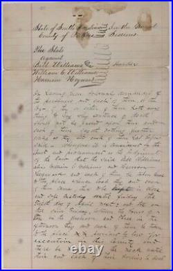
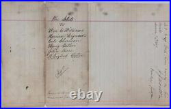
STATE OF SOUTH CAROLINA, COUNTY OF PICKENS, IN THE GENERAL SESSIONS. THE STATE AGAINST BILL WILLIAMS, ALIAS WILLIAM C. WILLIAMS, AND HARRISON HEYWARD, SENTENCED TO DEATH BY HANGING, MARCH 7, 1889. Title: STATE OF SOUTH CAROLINA, COUNTY OF PICKENS, IN THE GENERAL SESSIONS. Description: Single sheet, 35 cm. Manuscript document presumably in a clerical hand, on lined paper, approx. 145 words, signed by the presiding Judge J. The accused were charged with murder and sentenced to be hanged on Friday, April 5 [1889], between the hours of ten in the forenoon and three in the afternoon…. Old fold lines, some shallow chipping at edges, some soiling and spotting, and ink strikes through two words. Docketed on verso, The State vs. Williams, Harrison Heyward, Cato Sherman, Henry Bolton, John Reese, R. Gaylord Eaton, Recorded on page 119 129? According to a newspaper article in the Newberry Herald and News, Newberry, S. 12, 1888 Williams and Heyward, African Americans, were accused of being part of a group who hanged a white man accused of the rape and murder of a 14 year old African American girl, Lula Sherman, in the community of Central, Pickens County, South Carolina. The white man, Manz Waldrop, alias Manz Gooden, was removed from the wagon of the deputy assigned to transport him to Pickens for trial, and hanged by a group of African Americans on Dec. During the trial, the other defendants, Cato Sherman [Lula’s father], John Reese, and a white man R. Gaylord Eaton were found not guilty, and Henry Bolton received a new trial. The community of Central, South Carolina was troubled over the court decision to hold these two men accountable, and a petition campaign demanding clemency, with thousands of names, plus letters from prominent citizens, numerous news articles in the local papers, as well as detailed reports from the coroner’s inquests for both Lula Sherman and Manz Waldrop led the Governor John P. Richardson to pardon them. See: “Lynch Law Reversed: The Rape of Lula Sherman, the Lynching of Manse Waldrop, and the Debate over Lynching in the 1880s, ” by Bruce Baker, published in American Nineteenth Century History 6:3 Sept. 2005, for an analysis of the complicated nature of this case. Subject: African-Americana, Americana, Law. We are a Washington, D. Based bookstore in business for over 35 years. We specialize in Americana and general Antiquarian books. This listing was created by Bibliopolis.
State Of South Carolina County Of Pickens In The General Sessions The State
Large_Original_Antique_Civil_War_General_Topographical_Map_SOUTH_NORTH_CAROLINA_01_cx

Large Original Antique Civil War General Topographical Map SOUTH NORTH CAROLINA

Large Original Antique Civil War General Topographical Map SOUTH NORTH CAROLINA

Large Original Antique Civil War General Topographical Map SOUTH NORTH CAROLINA
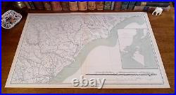
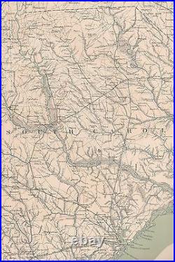
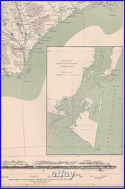
Original Plate of “The Official Atlas to Accompany the Official Records of the Union and Confederate Armies, ” Published the by the Resolution of the U. Congress of May 19. 1864, to serve asThe Official Historical Record of The Civil War, to be Accompanied by an Atlas of Battles, Troop Positions, Skirmishes, and Topography. Of the only 10,000 Published, less than 1,000 Complete Atlases Remain. Fine Adornment of Civil War History. Impressive on any Home or Office Wall. Topographical Map of 1865 South & North Carolina Intricate Detail. Original Topographical Plate CXXXIX (#139) of The Official Folio Historical Record of The Civil War contained within. The Official Atlas to Accompany the Official Records of the Union and Confederate Armies. Ordered by Act of Congress in 1864; Entered into The Library of Congress; and Published by the U. Publishing Office, Containing all Battle Maps, Field Reports, Correspondence, Troop Positions, Skirmishes, Coastal Surveys, Naval Battles, and Topography during the Four Years of the War – The undertaking of Accumulating and Assembling The Atlas taking over 30 years to complete. Original Plate CXXXIX (#139) of the 175 Published. Map is in Fine/Very Good condition No soils, marks, or writings. Minimal fraying along edges. No separation along indentation fold. Single fold as issued. Original Lithograph Engraved by Julius Bien for the. “The Official Atlas to Accompany the Official Records of the Union and Confederate Armies;”. Commissioned by Resolution of Congress May 19, 1864, in accordance to serve as The Official Historical Record of the War. The Atlas Entered the Public Domain when the Atlases were withdrawn from Libraries and Other Federal Depositories over the past Century. Only 10,000 Published, and Less than 1,000 Complete Atlases Remain. Impressive On Any Home or Office Wall. Dimensions: 19 ” x 29.5″. Map Shows Cities, Towns, Railroads, Rivers, Forts, & Many Other Landmarks. A Few of the Cities, Towns, Railroads, & Other Landmarks located on the Map: Charleston & Savannah Railroad, Darlington, Camden, Columbia, Charleston, Orangeburg, Wilmington Elizabethton, Moore’s Crossing, Taylor’s, Chesterfield, Hickory Head, Lancaster, Charleston Harbor, Fort Sumter, Cape Roman, Light House Inlet, Cape Fear, Green Swamp, Clay Valley, Onslow, Cape Lookout, Sumterville, Bennettsville, Conway, Old Court House, Tory Hole, Fear River, Lumberton, Cooper Hill, Springfield, Laurel Hill, Walkersville, Flat Rock, Kellytown, Gardner’s Gold Mine, and many others landmarks. Great for Genealogy & Family History as Map Shows Towns & Landmarks during the War; Some of Which No Longer Exist Today. The Atlas to Accompany The Official Records of the Union and Confederate Armies was Commissioned with Resolution of the U. Congress in 1864, by which Adjt. Townsend was Appointed Directorship of the Collection and Preparation of the Atlas, which was ultimately Completed and Published in 35 Parts in Sets of Five Lithographic Plates by the U. The 175 Plate Volume dedicated to Preserving a Historical Record of the War, each Map portraying a wealth of Knowledge and Information on Division, Corps, and Troop Positions; Battle Lines, Topography, and Military Strategy. A Frame is Not Included. The Framed Map shown is a Personal Lithograph of the Atlas Featured to Show the Beauty of the Maps when Framed. Greetings from Historical Savannah, Georgia: Founded 1733/. Some, to beautify their halls, parlors, chambers, and libraries… Loveth, getteth, and useth maps, charts, and geographical globes. John Dee, Advisor to Queen Elizabeth I. The free listing tool. This item is in the category “Antiques\Maps, Atlases & Globes\North America Maps”. The seller is “jonesjackson” and is located in this country: US. This item can be shipped worldwide.
  • Format: Topographical Map
  • Printing Technique: Lithography
  • Year: 1861
  • US State: South Carolina, North Carolina
  • City: Charleston
  • Country/Region: United States of America
  • Cartographer/Publisher: Julius Bien
  • Date Range: 1800-1899
  • Type: Civil War Map
  • Original/Reproduction: Antique Original

Large Original Antique Civil War General Topographical Map SOUTH NORTH CAROLINA