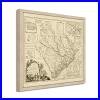


VINTAGE MAP FRAMED: You’ll love this high-quality framed historic reproduction of 1773 South Carolina Map. Our ready-to-hang maps are printed and framed in the USA by professional art framers using the highest quality materials. Each order is inspected for quality. This beautiful artwork is a perfect addition to your themed decor. Vintage maps look great in the home, study or office. They also make an unforgettable gift. A LOOK BACK AT HISTORY: This is an impressive, historic reproduction of 1773 South Carolina Wall Map. A true piece of history. Historic prints beautifully link the past with the present. You may find yourself staring at your historic wall art for hours in amazement. See our product description section for more fascinating information about this historic map and its significance. PREMIUM QUALITY: To display this amazing piece of history, we use museum-quality heavyweight (230gsm), fine art print matte paper. Our paper is acid-free which allows the print to retain its color quality for generations. Our paper displays vintage map art with accurate color reproduction. This high quality print will be a wonderful addition to your vintage-themed wall. READY TO HANG: This high-quality frame displays art beautifully in almost any environment. The frame is made out of poplar wood (for black and white) and pine wood (for walnut and natural) with a matte finish. The frame profile is 1.5 inches high and 0.75 inches wide. To protect artwork, we use high-quality, lightweight, shatter-resistant frame-grade acrylic. Frames arrive ready-to-hang, preinstalled with hanging hardware. HISTORIC PRINTS: We love history and art. Sometimes old maps have tears, folds, stamps, separations and other blemishes. We digitally restore and enhance maps while keeping its historical character. Our framed prints are made-to-order in the USA by professional art framers. Customers all over the world love our historic prints and we know you will too. Published just two years before the American Revolution broke out, this depiction of what would become South Carolina is highly detailed and would have been a valued resource at the time. By illustrating not just the towns and counties, but also topographical information, this map serves as a real link to the past and an authentic piece of cartographical history. This era in South Carolina, and the other twelve colonies, saw tensions rising against colonial rule by Great Britain, and the Boston Tea Party occurred in the same year this map was produced. Charlestown, the oldest and most populated city in South Carolina, was a valuable port and the busiest hub of Atlantic trade between the colonies and England. In addition, the huge amount of business that occurred in Charlestown made it the most prosperous city in North America at this time. Tobacco exports flourished, and the state developed widespread rice cultivation in its marshy lowlands. South Carolina’s rich history goes back to the first settlers of the land who found fertile ground for farming as well as valuable marine life and the ability to establish deepwater ports. Five years after the publication of this map South Carolina would be the first state to ratify the Articles of Confederation and would go on to become the eighth state to join the fledgling nation. During the American Revolution, the state saw nearly a third of all conflicts on its land, more than any other state, as residents endured invasion by the English. Our ready-to-hang wall art are printed and framed in the USA using the highest quality materials with professional craftsmanship. Historic prints look great in the home, study or office.

")